Yesterday I headed to the North, so today Iwent to the South.
The aim is “Pikes Peak” Mountain.
I drove along I-25 from Denver to ColoradoSprings first.
I saw Rocky Mountains in the right side andGreat Plains in the left.
About 1.5 hour drive let me in ColoradoSprings.
I took a rest here.
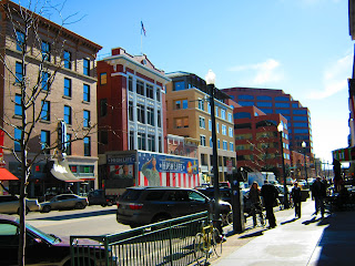
This is quite small city compared toDenver.
This is Pioneer Museum.
If I had had a time, I would have gone tothis museum, but unfortunately I saw only outside.
While walking in the downtown, I also founda cute egg.
The view of today’s goal from is like this.
Well, I ate sandwich and departed.
Next I used US-24 highway.
I could tell that gradually I was going up.
After 10 mile driving, I entered Pikes PeakHighway.
About 20 miles way to top
In the beginning, I paid $10 as toll fee.
This is the view from the place near thegate.
The higher place I went, the more theamount of snow.
Gradually I found snow even in the road…
Here there is no tree because of highaltitude!!
And… finally I got to the top!!
Yes I made it!
I took a memorial picture!
This point is 14,110 feet (4,300m) abovethe sea level.
4300m !?
I stood higher place than Mt. Fuji, whichis the highest mountain in Japan!
My nose was red, you know.
It was extremely cold!!
The scenery from the top is very nice!!
〈East wiew〉
〈North view〉
〈Northwest view〉
〈South view〉
I was there for only 20 min.
I couldn’t stand such a cold place…
Well, let’s descend a mountain!
Different from ascent, it was so scary thatI thought I would die…
There is much snow on the road but no guardrail.
For 1 hour it was hell time.
Now I am alive. Thanks god…
Today I had driven for about 8 hours andran 200miles (320km).
I was a beginner of driver, but my skill ofdriving raised up.
I drove mountain road and night road!
Today is wonderful day in my trip.
I experienced awesome things that I can’t usuallydo.
It was quite great for me that I could goto the top…


Red Rose!^^
ReplyDelete